A hike to Gregory Bald in Cades Cove is the perfect way to experience the beauty and tranquility of nature. You’ll get the chance to see beautiful mountain views and diverse plant life, including colorful wildflowers. This is one of the more difficult hikes in Cades Cove, but it’s also very popular because of all the amazing sights to see. Here’s everything you need to know about hiking to Gregory Bald in Cades Cove.
About Gregory Bald
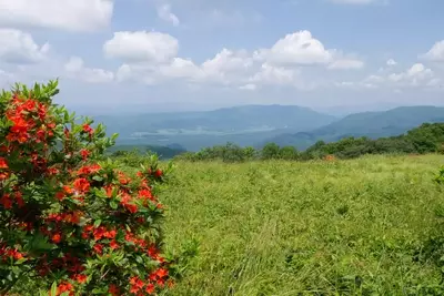
 Gregory Bald in Cades Cove is a beautiful hiking destination. A bald is an area of flat meadow-covered land that can be found along a mountain ridge. Gregory Bald was formed from Elkmont sandstone, and if you look closely, you can see this rock peeking through the thick grass. The bald was named after Russell Gregory, who was an early settler in the Cades Cove area. He and other settlers grazed their cattle in the meadow. The location of Gregory Bald allows hikers to see a variety of mountain ranges all around. On a clear day, you may be able to see Cades Cove, Rich Mountain, Thunderhead Mountain, Kuwohi (formerly Clingmans Dome), Fontana Lake, the Yellow Creek Mountains, and more. Depending on the time of year, you may get to see colorful azaleas and even wild blueberries at the top of Gregory Bald.
Where to Find the Trailhead
Gregory Bald is one of the most popular hikes in Cades Cove. To access Gregory Bald, you can hike the Gregory Bald Trail. This trailhead can be found at Sams Gap on Parson Branch Road. From the Cades Cove Loop Road, take Forge Creek Road. After driving 2.2 miles, you’ll reach Parson Branch Road. Here you’ll pass the Gregory Ridge Trailhead, which is another trail you can take to reach Gregory Bald. Continue 3.3 miles down Parson Branch Road to reach the Gregory Bald Trailhead at Sams Gap. Keep in mind that Parson Branch Road is a one-way road, so if you do not want to take the road all the way to its end at Highway 129, you may want to consider hiking the longer Gregory Ridge Trail instead.
Hiking the Gregory Bald Trail
 The hike to Gregory Bald via the Gregory Bald Trail is 8.8 miles roundtrip. With an elevation gain of 2,300 feet, this hike is considered strenuous. From the trailhead, the first mile of the hike is fairly easy. After this point, the rest of the hike is a steady climb the rest of the way to the top of Gregory Bald. The trail passes through an old-growth forest with diverse plant life including large eastern hemlocks. At approximately 4.1 miles, you will reach Backcountry Campsite 13 at Sheep Pen Gap. At the junction, bear to the left to continue towards Gregory Bald. You’ll reach Gregory Bald after about a third of a mile. When you reach the bald, you can take in majestic views and rest before making your way back down.
Safety Tips for Hiking in Cades Cove
If you’re planning to hike the Gregory Bald Trail or one of the many other great hiking trails in Cades Cove, make sure you follow all the necessary safety precautions. Take a look at these hiking safety tips for trails in Cades Cove so you can have a safe, successful hike while exploring the natural beauty of this amazing section of the Great Smoky Mountains National Park!


